


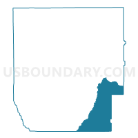
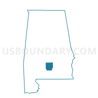
CENTRAL HILL, Butler County, Alabama
About
Outline

Summary
| Unique Area Identifier | 521291 |
| Name | CENTRAL HILL |
| County | Butler County |
| State | Alabama |
| Area (square miles) | 67.13 |
| Land Area (square miles) | 67.13 |
| Water Area (square miles) | 0.00 |
| % of Land Area | 100.00 |
| % of Water Area | 0.00 |
| Latitude of the Internal Point | 31.60593150 |
| Longtitude of the Internal Point | -86.53748220 |
Maps

Graphs
Select a template below for downloading or customizing gragh for CENTRAL HILL, Butler County, Alabama


Neighbors
Neighoring Voting District (by Name) Neighboring Voting District on the Map
- Buck Creek-Brooks, Covington County, AL
- CENTRAL VOLUNTEER FIRE DEPT., Butler County, AL
- FRIENDSHIP SCHOOL HOUSE, Butler County, AL
- INDUSTRY SCHOOL HOUSE, Butler County, AL
- Marvin Adams, Covington County, AL
- MCKENZIE CITY HALL, Butler County, AL
- MIDWAY, Butler County, AL
- Pleasant Home School, Crenshaw County, AL
Top 10 Neighboring County Subdivision (by Population) Neighboring County Subdivision on the Map
- Andalusia CCD, Covington County, AL (18,495)
- Greenville CCD, Butler County, AL (13,363)
- Luverne CCD, Crenshaw County, AL (6,989)
- Georgiana-McKenzie CCD, Butler County, AL (4,341)
- Brantley CCD, Crenshaw County, AL (3,089)
Top 10 Neighboring Unified School District (by Population) Neighboring Unified School District on the Map
- Covington County School District, AL (22,091)
- Butler County School District, AL (20,947)
- Crenshaw County School District, AL (13,906)
Top 10 Neighboring State Legislative District Lower Chamber (by Population) Neighboring State Legislative District Lower Chamber on the Map
Top 10 Neighboring State Legislative District Upper Chamber (by Population) Neighboring State Legislative District Upper Chamber on the Map
Top 10 Neighboring 111th Congressional District (by Population) Neighboring 111th Congressional District on the Map
Top 10 Neighboring Census Tract (by Population) Neighboring Census Tract on the Map
- Census Tract 9532, Butler County, AL (4,327)
- Census Tract 9617, Covington County, AL (4,032)
- Census Tract 9636, Crenshaw County, AL (3,180)
- Census Tract 9638, Crenshaw County, AL (1,681)
- Census Tract 9535, Butler County, AL (1,410)
Top 10 Neighboring 5-Digit ZIP Code Tabulation Area (by Population) Neighboring 5-Digit ZIP Code Tabulation Area on the Map
- 36037, AL (14,074)
- 36033, AL (4,299)
- 36474, AL (2,926)
- 36009, AL (2,566)
- 36456, AL (1,820)
- 36028, AL (1,746)
- 36071, AL (766)